The page provides access to both real time and archived contrail formation forecasts from Rapid Update Cycle (RUC) model data.
The RUC model data are representations of the complete 3-dimensional structure of wind, temperature, and humidity over the USA at a resolution of 25 mb and 40 km. The horizontal resolution has been degraded to 1° latitude x 1° longitude to facilitate the computations. Because they are based on a sparse number of actual in situ (balloon sonde) data taken every 12 hours and satellite measurements, the RUC data are not a perfect representation of the various meteorological parameters, especially water vapor. The model humidity at upper levels of the atmosphere is often too low, reflecting the current biases known to exist in our measurement system. Persistent contrails require a relative humidity with respect to ice (RHI) that exceeds 100%. We know that contrails are sometimes observed in areas where estimates of the RHI are less than 100%. The existence of contrails in those locations highlights the "dry-bias" in the humidity fields.
Because the input data do not perfectly characterize the meteorological conditions, the diagnoses of persistent contrail conditions are only estimates and will not detect all of the areas where persistent contrails will form and may also add areas of formation that do not exist. All estimates of persistent contrail formation conditions are based on a modified Appleman curve using three different engine propulsion efficiencies. To give some idea of where contrails may form, but are not diagnosed, we have included information about RHI for values above 70% for single-level plots.
Two forms of results are presented.
The contrail forecast software was developed by Dr. David Duda of Hampton University with Patrick Minnis (NASA), with support from the NASA Office of Earth Science Pathfinder Program. The near-real time display was constructed by Rabindra Palikonda (SSAI). For more information contact Dr. Duda ( d.p.duda@larc.nasa.gov ) or Dr. Minnis (p.minnis@larc.nasa.gov).
The relative humidity data from the RUC 40km model are suspect since 18 April, 2002. Therefore, all contrail forecasts since April 18, 2002 are suspect.To obtain a better estimate of potential contrail formation, examine the 'Individual level (mb)' results. Select a pressure value between 200 and 250 mb for the best estimate. Relative humidity values above 80% are good indicators of contrails in the new RUC data. You can use any pressure level , but the large values may be too warm for contrail formation.
|
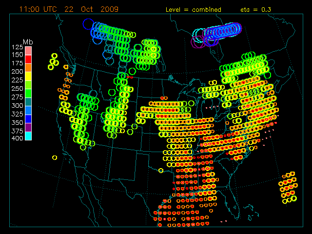
This is the latest forecast image for the combined levels ( 400 - 150 mb ).
|